What is this precision agriculture and how electronics technology is applied
What if farmers have eyes in the sky to monitor farm lands in real-time! In a large area stretching tens of kilometres where single or multiple crops are grown, monitoring their growth through satellite imaging or drones is helping to manage crop cultivation better. Taking visual, Infrared or some such crop yield indicating scanned images (Spectral Imaging) is driving what is called precision agriculture/farming. It is not a technology in labs, it is already being implemented in countries like USA , Canada and many regions. Some experts call this data driven agriculture.
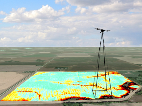
Multi and hyperspectral cameras are fitted to drones enabled with a GPS/GNSS systems and controlled by ground systems again through GPS/GNSS data. These drones bring back the pictures for the farmer and agriculture scientists to find out why some patches of land giving good yield. The water content, the soil nature, pests, Soil PH, and also photosynthesis, level can be analysed through various scans. Invisible spectrum can be used to detect the amount of pesticides and insecticides in the soil or sprayed over the plants. Tasks such as soil variation identification, pests and fungal infestations, identifying healthy and distressed plants, can be achieved faster with drones compared to personal inspe...
Multi and hyperspectral cameras are fitted to drones enabled with a GPS/GNSS systems and controlled by ground systems again through GPS/GNSS data. These drones bring back the pictures for the farmer and agriculture scientists to find out why some patches of land giving good yield. The water content, the soil nature, pests, Soil PH, and also photosynthesis, level can be analysed through various scans. Invisible spectrum can be used to detect the amount of pesticides and insecticides in the soil or sprayed over the plants. Tasks such as soil variation identification, pests and fungal infestations, identifying healthy and distressed plants, can be achieved faster with drones compared to personal inspe...
You've read this far — sign in to keep reading